


The Ottoman dominions in Europe
Turkey in Europe.
London, J. & F. Tallis, c.1851. Steel engraving with original outline colour. Printed area 330 x 265mm.
£130.00
Description
Detailed Victoria map of the Balkans with an inset of Crete, within an ornate printed border and decorated with three vignettes including a prospect of Istanbul from the Bosphorus.
The map was drawn and engraved by John Rapkin for the 'The Illustrated Atlas, and Modern History of the World, Geographical Political, Commercial & Statistical', edited by Montgomery Martin, which was one of the last decorative atlases to be published.
Condition:
A little creasing on lower edge.Related products
-

A 16th century map of Kotor, Montenegro
ROSACCIO, Giuseppe. Date: 1598Stock #: 25631 £220.00 -
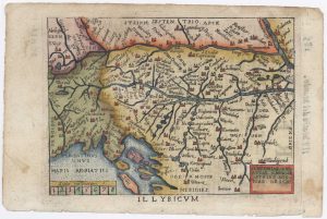
Miniature map of Dalmatia
ORTELIUS, Abraham. Date: 1655Stock #: 9016 £120.00 -

A scarce 18th century map of Istria.
CAPELLARIS, Giovanni Antonio, Date: 1797Stock #: 25315 £1,200.00 -

A 16th century town plan of Dubrovnik
VALEGIO, Francesco. Date: 1598Stock #: 24175 £250.00 -

A 16th century Italian map of Bar, Montenegro
ROSACCIO, Giuseppe. Date: 1598Stock #: 25042 £240.00 -

Scarce 16th century Venetian plan of Ulcinj
CAMOCIO, Giovanni Francesco. Date: 1575Stock #: 13508 £400.00 -

The Venetian fort of Zadar in Croatia
CORONELLI, Vincenzo Maria. Date: 1700Stock #: 23365 £350.00 -
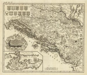
An uncommon 18th century map of Dalmatia
MONATH, Peter Conrad. Date: 1723Stock #: 22156 £980.00 -

An 18th century chart of Split, Croatia
ROUX, Joseph. Date: 1764Stock #: 21737 £80.00
Items by the same author
[ti_wishlists_addtowishlist]

Mid 19th century map of Ireland with decorative vignettes
TALLIS, John. Date: 1851 Stock #: 21568 £240.00
[ti_wishlists_addtowishlist]

A mid-19th century map of Germany with decorative vignettes
TALLIS, John. Date: 1851 Stock #: 23486 £120.00
[ti_wishlists_addtowishlist]

[ti_wishlists_addtowishlist]

[ti_wishlists_addtowishlist]

Mid 19th century map of Greece with decorative vignettes
TALLIS, John. Date: 1851 Stock #: 23523 £140.00
[ti_wishlists_addtowishlist]
