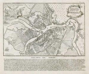
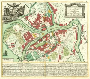
18th century plan of St Petersburg
Nova ac Verissima Urbis St. Petersburg ab Imperatore Russico Petro Alexii F. conditae, item Fl. Nevae, Fossae Jussu Imp. Russ. factae, ac regionis circumiacnetis Delineatio
Amsterdam: the Widow of J. Ottens, c.1765. Original colour. 520 x 600mm.
£1,600.00
1 in stock
x
Question About This Item?
18th century plan of St Petersburg & OTTENS, Reinier & Joshua.Stock #: 22699Similar to Sell?
Description
A scarce issue, featuring two maps on one sheet. Below is a detailed map of St Petersburg, with the proposed development of the island Wasili Osterow, with a Dutch-style grid of canals. Above is a map of the environs of the city, with the course of the Neva river.
Condition:
A good example.Related products
-

Complete set of ten views of St Petersburg by Lespinasse
LESPINASSE, Louis Nicolas de. Date: 1794Stock #: 19702 £5,750.00 -
View of St Petersburg by night
LEBRETON, Louis. Date: 1855Stock #: 17096 £450.00 -
View of Kronstadt
MANDEVILLE, H. Date: 1854Stock #: 17090 £130.00 -
18th century town plan of St Petersburg
HAAS, Johann Matthias. Date: 1750Stock #: 17686 £600.00 -
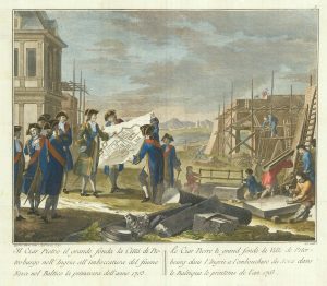
The founding of St Petersburg by Peter the Great
ZATTA, Antonio. Date: 1797Stock #: 24504 £700.00 -
A plan of St Petersburg from Russian Sources
SEUTTER, Matthaus. Date: 1744Stock #: 18367 £1,850.00
Items by the same author
[ti_wishlists_addtowishlist]

An 18th century map of the Republic of Genoa
OTTENS, Reinier & Joshua. Date: 1730 Stock #: 24821 £600.00
[ti_wishlists_addtowishlist]