


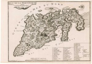
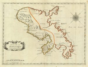
17th century map of Martinique in fine colour
Insula Matanino vulgo Martanico...
Amsterdam, 1657. Full original colour. 470 x 570mm.
£600.00
1 in stock
x
Question About This Item?
17th century map of Martinique in fine colour & VISSCHER, Nicolas Jansz.Stock #: 24747
Add to Wishlist
Export as PDFEnquireSimilar to Sell?Add to Wishlist
Description
A large map of Martinique, during the conquest of the island by the French. North on the compass rose errs by 45° East.
In 1635 the 'Compagnie des Îles de l'Amérique' sent nearly a hundred settlers from St Kitts to Martinique, where they built Fort St Pierre. On the map the island is divided in two with 'Demeure de Francois' to the north and west, and 'Demeure de Sauvages' (the indigenous Caribs) over the rest of the island. The map does not mention Fort St Louis, a second fort built by the French in 1638. The Caribs were exterminated or exiled by 1660.
Condition:
Faint glue stains at centre fold, small repairs to verdigris on reverse.Related products
-
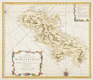
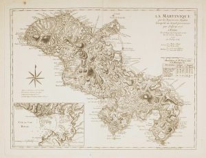
Detailed map of Martinique published during the Seven Years’ War
BELLIN, Jacques-Nicolas. Date: 1762Stock #: 14635 £600.00 -
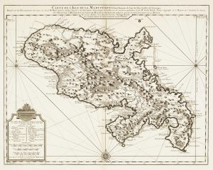
18th century map of Martinique
COVENS & MORTIER. Date: 1740Stock #: 12311 £650.00 -
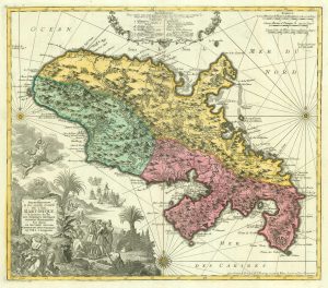
18th century map of Martinique in fine colour
SEUTTER, Matthaus. Date: 1730Stock #: 19343 £550.00 -
Early 18th century map of Martinique
FER, Nicolas de. Date: 1704Stock #: 18419 £250.00 -
Map of 18th-century Martinique
JEFFERYS, Thomas. Date: 1779Stock #: 12317 £550.00 -
A scarce 17th century French map of Martinique
MARIETTE, Pierre. Date: 1650Stock #: 21841 £400.00
Items by the same author
Add to Wishlist
Add to Wishlist

17th century Dutch map of Spain and Portugal in fine colour
VISSCHER, Nicolas Jansz. Date: 1680 Stock #: 22490 £750.00
Add to Wishlist
Add to Wishlist

Morea during Venetian rule
VISSCHER, Nicolas Jansz. Date: 1698 Stock #: 15291 £650.00
Add to Wishlist
Add to Wishlist

17th century Dutch map of Portugal in fine colour
VISSCHER, Nicolas Jansz. Date: 1680 Stock #: 20843 £340.00
Add to Wishlist
Add to Wishlist

17th century map of Denmark
VISSCHER, Nicolas Jansz. Date: 1670 Stock #: 20730 £475.00
Add to Wishlist
Add to Wishlist
