


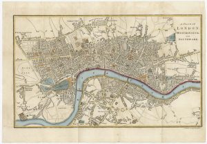
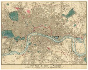
A four-sheet wall map of London
A New Plan of London, XXIX Miles in Circumference.
London: Stockdale, 1797-c.1809. Coloured. Four sheets conjoined, total 1020 x 1460mm.
£9,000.00
Description
A large and detailed map of London, first issued in 1797, this example updated c.1809 but retaining the original publication date. Engraved by S. J. Neele, the '29 miles' encompasses Kensington Palace in the west clockwide to Hampstead, Kentish Town, Clapton, Stratford, Poplar, Greenwich, Camberwell & Chelsea.
This state has the East & West India Docks, and the Grand Junction & Croydon Canals added, with the planned Vauxhall Bridge and Road marked (opened 1816). The outline of Regent's Park, created when the farm leases expired in 1811, has yet to appear. Thus 'Jew's Harp House', a tea house mentioned in William Blake's epic poem 'Jerusalem', is still shown.
Condition:
Backed on linen.References:
HOWGEGO No. 213 1(a).Related products
-
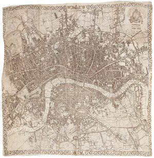
A very scarce handkerchief map of London
Anonymous. Date: 1832Stock #: 20799 £2,800.00 -
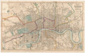
A large plan of London in 1863
OUTHETT, John. Date: 1863Stock #: 24116 £1,600.00 -
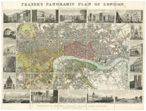
Plan of London during the reign of William IV
FRASER, James. Date: 1831Stock #: 19889 £1,100.00 -
Nineteenth century townplan of London
BAKER, B. Date: 1810Stock #: 24770 £450.00 -
Detailed map of London during the Great Exhibition of 1851
CARY, John. Date: 1851Stock #: 24101 £1,500.00 -
Map of London at the beginning of the 18th century
FER, Nicolas de. Date: 1705Stock #: 23204 £400.00 -

A map of London during the Interregum
NEWCOURT, Richard. Date: 1878Stock #: 25458 £6,850.00 -
London during the Great Exhibition of 1851
TALLIS, John. Date: 1851Stock #: 25662 £2,400.00 -
A French edition of Rocque’s map of London
TARDIEU, Pierre François. Date: 1765Stock #: 22729 £800.00
Items by the same author
Add to Wishlist
Add to Wishlist

A town plan of Dresden
STOCKDALE, John. Date: 1800 Stock #: 23701 £125.00
Add to Wishlist
Add to Wishlist
