


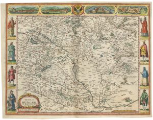
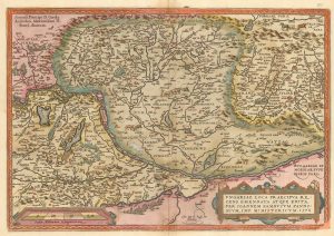
A 16th century miniature map of Hungary
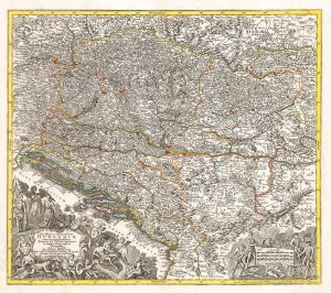
Hungaria.
Amsterdam, Cornelis Claez, 1599, Dutch text edition. 85 x 125mm, with letterpress surtitle and pagination.
£110.00
Description
A scarce map of Hungary, engraved by either Jodocus Hondius or Pieter van der Keere for the 'Caert-Thresoor', with a text by an unknown author. Despite being published only a year after the first edition, this is a second state: the right border has been re-engraved with latitude graduations.
By 1600 this map was being published in the 'Tabularum Geographicarum Contractarum' with a text by Petrus Bertius, and in 1616 a new plate was engraved by Jodocus Hondius II, slightly larger and with wider borders with scales of longitude and latitude.
Condition:
A good example.Related products
-
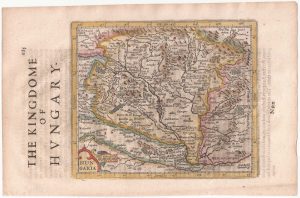
A rare issue of Speed’s famous 17th century map of Hungary
SPEED, John. Date: 1665Stock #: 23990 £1,500.00 -
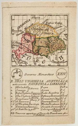
An 18th century playing-card map of Hungary
RABATTA, Augusto & BAILOU, Jean Baptist de. Date: 1779Stock #: 13003 £380.00 -
Hungary from the first English Edition of the ‘Atlas Minor’
HONDIUS, Jodocus. Date: 1635Stock #: 22392 £170.00 -
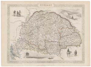
A mid 19th century map of Hungary with decorative vignettes
TALLIS, John. Date: 1851Stock #: 21625 £125.00 -
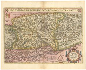
Ortelius’s map of Hungary in fine colour
ORTELIUS, Abraham. Date: 1612Stock #: 23811 £650.00 -
Ortelius’s map of Hungary in fine original colour
ORTELIUS, Abraham. Date: 1603Stock #: 23806 £600.00 -
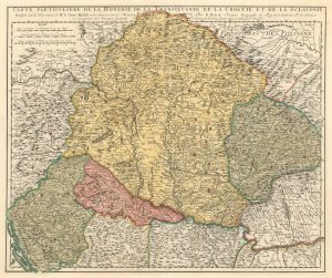
Early 18th century map of Hungary, with Transilvania, Croatia and Slovenia
SCHENK, Pieter. Date: 1717Stock #: 17948 £300.00 -
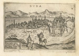
A 16th century Italian plan of Buda
VALEGIO, Francesco. Date: 1598Stock #: 24150 £600.00 -
An 18th century map of Hungary and the northern Balkans
SEUTTER, Matthaus. Date: 1760Stock #: 22732 £380.00
Items by the same author
Add to Wishlist
Add to Wishlist

A 16th century miniature map of Scandinavia
LANGENES, Barent. Date: 1602 Stock #: 22481 £340.00
Add to Wishlist
Add to Wishlist

A 16th century miniature map of Saxony, Thuringia & Meissen
LANGENES, Barent. Date: 1599 Stock #: 21173 £50.00
Add to Wishlist
Add to Wishlist

A 16th century miniature map of Pomerania
LANGENES, Barent. Date: 1599 Stock #: 21175 £65.00
Add to Wishlist
Add to Wishlist

A 16th century miniature map of Dithmarschen
LANGENES, Barent. Date: 1599 Stock #: 21169 £55.00
Add to Wishlist
Add to Wishlist

A 16th century miniature map of the Comtat Venaissin
LANGENES, Barent. Date: 1599 Stock #: 21137 £55.00
Add to Wishlist
Add to Wishlist
