


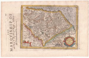
A 16th century miniature map of Ancona and surroundings
Marcha Anconae olim Picenum. 1572.
Amsterdam, Cornelis Claez, 1599, Dutch text edition. 85 x 125mm, with letterpress surtitle and pagination.
£180.00
1 in stock
x
Question About This Item?
A 16th century miniature map of Ancona and surroundings & LANGENES, Barent.Stock #: 21355
Add to Wishlist
Export as PDFEnquireSimilar to Sell?Add to Wishlist
Description
A scarce map of the Marche region, orientated with north to the bottom of the map, engraved by Pieter van der Keere for the 'Caert-Thresoor', with a text by an unknown author. Despite being published only a year after the first edition, this is a second state: the left border has been re-engraved with latitude graduations.
By 1600 this map was being published in the 'Tabularum Geographicarum Contractarum' with a text by Petrus Bertius, and in 1616 a new plate was engraved by Jodocus Hondius II, slightly larger and with wider borders with scales of longitude and latitude.
Condition:
A good example.Related products
-
Ancona from the first English Edition of the ‘Atlas Minor’
HONDIUS, Jodocus. Date: 1635Stock #: 22395 £180.00 -
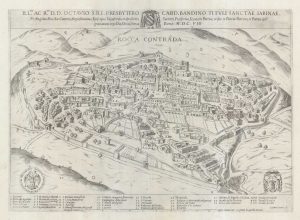
A very scarce plan of Arcevia
LAURO, Giacomo. Date: 1608Stock #: 18989 £950.00 -
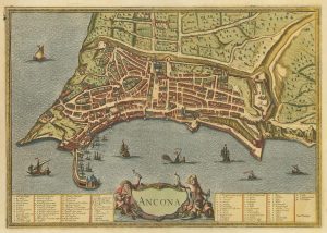
17th century miniature map of Ancona
HONDIUS, Jodocus. Date: 1610Stock #: 18360 £220.00 -
A late 17th century re-issue of Braun & Hogenberg’s plan of Ancona
BRAUN, Georg & HOGENBERG, Frans. Date: 1657Stock #: 21907 £550.00
Items by the same author
Add to Wishlist
Add to Wishlist

A 16th century miniature map of Scandinavia
LANGENES, Barent. Date: 1602 Stock #: 22481 £340.00
Add to Wishlist
Add to Wishlist

A 16th century miniature map of Saxony, Thuringia & Meissen
LANGENES, Barent. Date: 1599 Stock #: 21173 £50.00
Add to Wishlist
Add to Wishlist

A 16th century miniature map of Pomerania
LANGENES, Barent. Date: 1599 Stock #: 21175 £65.00
Add to Wishlist
Add to Wishlist

A 16th century miniature map of Dithmarschen
LANGENES, Barent. Date: 1599 Stock #: 21169 £55.00
Add to Wishlist
Add to Wishlist

A 16th century miniature map of the Comtat Venaissin
LANGENES, Barent. Date: 1599 Stock #: 21137 £55.00
Add to Wishlist
Add to Wishlist
