

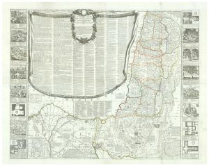
Uncommon 17th century panelled map of the Holy Land
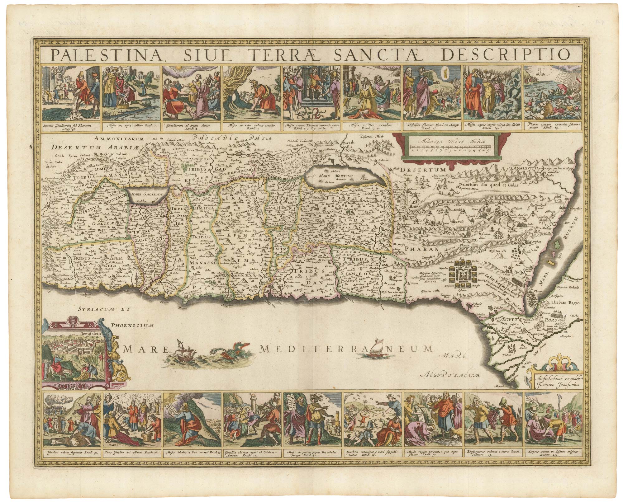
Palestina sive Terrae Sanctae Descriptio.
Amsterdam: Jan Jansson van Waesberge, c.1677, blank verso. Old colour. Size: 440 x 570mm.
£3,500.00
1 in stock
x
Question About This Item?
Uncommon 17th century panelled map of the Holy Land & JANSSON, Jan.Stock #: 21897
Add to Wishlist
Export as PDFEnquireSimilar to Sell?Add to Wishlist
Description
A very fine example of one of the most decorative maps of the Holy Land, based on Adrichom and orientated with north to the left, with 18 inset scenes from Genesis, Exodus & Numbers, and a nineteenth depicting Jesus approaching Jerusalem on the donkey. This map did not appear in many atlases, supplanted by Henricus Hondius's less decorative but more contemporary map. As this example has no text it is likely to have been published in Georg Horn's atlas of the ancient world, issued by Jansson's son-in-law.
Condition:
A good example.References:
LAOR: 372; NEBENZAHL: p119, plate 43, 'impressive'.Related products
-
A 16th century miniature map of the Holy Land
ORTELIUS, Abraham. Date: 1593Stock #: 24462 £225.00 -
A minature map of the Holy Land
BERTIUS, Petrus. Date: 1609Stock #: 24848 £200.00 -
A 16th century pilgrimage to Jerusalem
ZUALLART, Jean. Date: 1595Stock #: 23825 £3,200.00 -
A rare wall map of the Holy Land
NOLIN, Jean Baptiste. Date: 1785Stock #: 24500 £9,000.00 -
A 16th century map of the Holy Land from a ‘Geneva Bible’
POSTEL, Guillaume. Date: 1599Stock #: 24852 £220.00 -
16th century map of the Eastern Mediterranean in rare early colour
MUNSTER, Sebastian. Date: 1550Stock #: 24441 £880.00 -

A 16th century woodcut map of the Holy Land & Cyprus
MUNSTER, Sebastian. Date: 1550Stock #: 25482 £220.00 -
Map of the Holy Land and Cyprus for a history of the Crusades
DELISLE, Guillaume. Date: 1780Stock #: 20578 £750.00 -
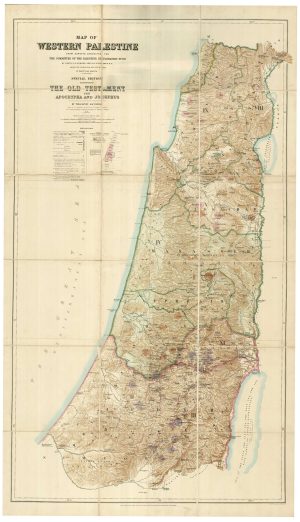
A special edition of Kitchener’s important map of Palestine
CONDER, C.R. & KITCHENER, H.H. Date: 1628Stock #: 25131 £1,100.00
Items by the same author
Add to Wishlist
Add to Wishlist

A magnificent example of the first folio sea atlas of the World
JANSSON, Jan. Date: 1650 Stock #: 23074 £47,500.00
Add to Wishlist
Add to Wishlist
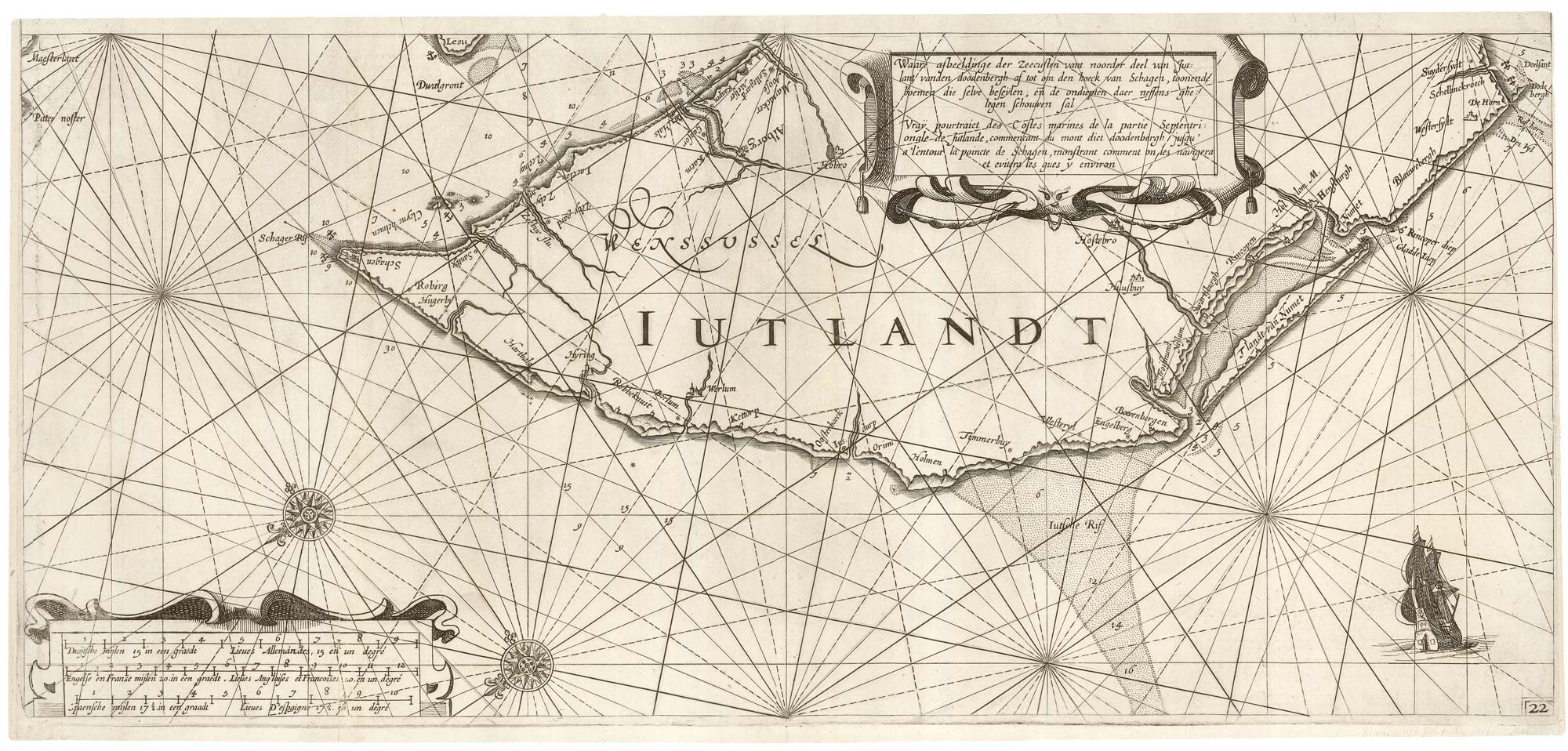
A rare 17th century sea chart of Jutland
JANSSON, Jan. Date: 1620 Stock #: 25262 £2,000.00
Add to Wishlist
Add to Wishlist

A 17th century map of Ireland from a pocket atlas
JANSSON, Jan. Date: 1631 Stock #: 25065 £325.00
Add to Wishlist
Add to Wishlist

An early issue of Jansson's map of Ireland
JANSSON, Jan. Date: 1638 Stock #: 23865 £950.00
Add to Wishlist
Add to Wishlist

Map of the River Elbe with a prospect of Hamburg
JANSSON, Jan. Date: 1630 Stock #: 24816 £500.00
Add to Wishlist
Add to Wishlist
